
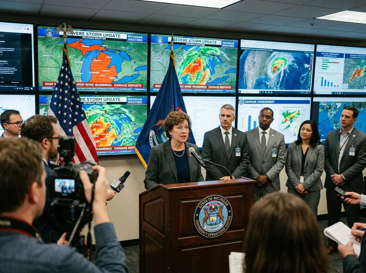
A single supercell that formed over Indiana on Thursday afternoon tracked northeast into lower Michigan and killed four people across two counties, injured at least 12 more, and left a corridor of destruction through three communities that the National Weather Service is still surveying. Three of the dead were in the Union Lake area of Branch County, about two hours west of Detroit. A fourth person died in Cass County, near the Indiana border. By Friday evening, Governor Gretchen Whitmer had activated the State Emergency Operations Center, Cass County had declared a state of emergency, and more than 6,800 utility customers across the region were still without power.
The storm system that spawned the Michigan tornadoes also produced deadly weather across the central United States, with at least two additional deaths confirmed in Beggs, Oklahoma, where a tornado cut a four-mile path through Okmulgee County. Across both states, CBS News reported a combined toll of at least six dead from the same weather event. But it is the Michigan leg of the outbreak that has drawn particular attention from meteorologists and emergency management officials, because violent tornadoes in the state during March are exceptionally rare, and the death toll makes this the state's deadliest outbreak of violent weather so far this century.
A Lone Supercell With an Unusual March Path
The storm that caused the destruction did not arrive as part of a sprawling severe weather outbreak. Instead, it began as a single supercell that developed during the afternoon of March 6 over La Porte County, Indiana, then tracked steadily northeast into Michigan's lower peninsula. According to the NWS office in Northern Indiana, the cell moved through Cass, St. Joseph, and Branch counties between approximately 3:11 PM and 4:38 PM EST, producing confirmed tornado damage in Edwardsburg, Three Rivers, and Union City.
The NWS issued 10 tornado warnings over a span of roughly three hours as the system moved across southwest Michigan, also threatening golf-ball-sized hail. Environmental conditions that afternoon favored tornado development despite only a Marginal Risk designation from the Storm Prediction Center. Helicity values of 200 to 250 m²/s² and wind shear of 40 to 50 knots provided the rotational energy the supercell needed. Those numbers would be unremarkable for a May afternoon in Kansas, but for early March in Michigan, they were striking. A warm front pushing northward from the Gulf of Mexico combined with an approaching weather system to create the right ingredients in a state where tornadoes at this time of year are genuinely unusual.

Three Communities, Three Different Kinds of Damage
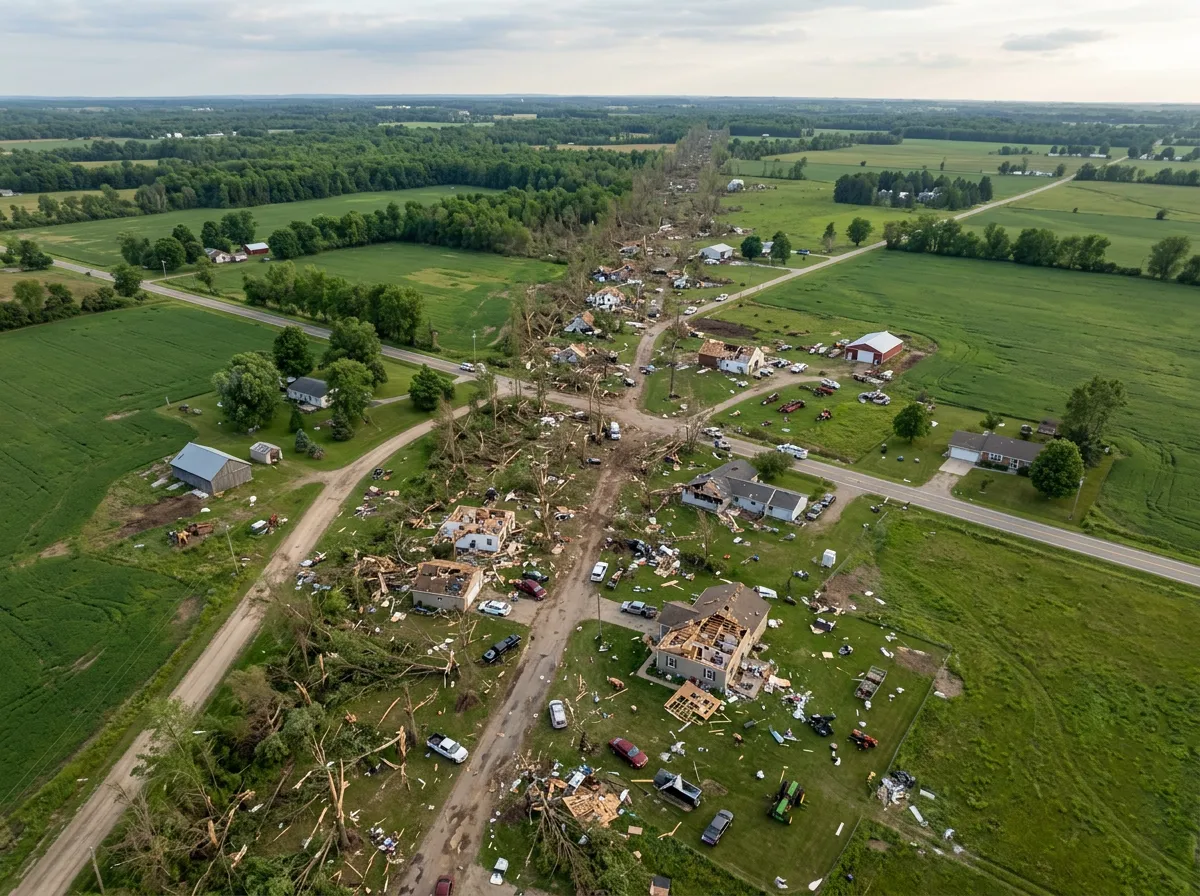
The tornado's path left distinct marks on each community it struck, and the damage tells a story about what the storm hit as much as how strong it was.
In Edwardsburg, located in Cass County near the Indiana state line, multiple large structures along Conrad Road west of the town and extending to M-62 were damaged or completely destroyed. The sole fatality in Cass County occurred in this area, and several additional injuries were reported. County officials declared a state of emergency Friday, citing the scale of structural damage and the number of blocked roads throughout the area.
In Three Rivers, roughly 20 miles south of Kalamazoo in St. Joseph County, the tornado ripped through a commercial corridor along US-131 and Broadway. Witnesses described watching the funnel cloud careen across a strip mall parking lot, rocking cars and sending debris spiraling. Video footage captured the moment a Menards hardware store lost a large section of its roof, with the back of the main building collapsing. A Dollar Tree and multiple storage units in the same area sustained heavy damage. Three Rivers Health Hospital was also struck, sustaining damage but remaining open to treat injured residents. The St. Joseph County Sheriff urged people to avoid Three Rivers and Fabius Township entirely, warning of power outages, closed roadways, and cellular disruptions.
The hardest-hit area was the north shore of Union Lake in Union City, Branch County. There, numerous homes sustained what emergency officials described as damage ranging from major structural impacts to complete destruction. Trees were sheared off at their trunks. Debris littered streets in every direction. The Branch County Sheriff's Office confirmed three deaths in this area along with 12 injuries, with three people transported to hospitals. In a small detail that captured the randomness of tornado damage, CBS News reported that the nearly 150-year-old grand piano at First Congregational United Church of Christ in Union City survived despite partial damage to the church itself.
Why March Tornadoes in Michigan Should Alarm Forecasters
The Washington Post noted Friday that what made this tornado "so striking" was its timing and location. Michigan is not immune to tornadoes, but they are concentrated overwhelmingly in the late spring and summer months. The state's tornado climatology peaks sharply in June and July, when warm, moist air from the Gulf of Mexico reliably clashes with jet stream energy crossing the upper Midwest. March tornadoes in Michigan are statistical outliers. Between 1950 and 2020, Michigan averaged fewer than 0.5 tornadoes per year in the month of March, according to NOAA's Storm Events Database. Most years recorded none at all.
That rarity is what makes Thursday's event so significant from a meteorological perspective. The warm front that enabled the supercell pulled Gulf moisture far enough north to create a thermodynamic environment that Michigan almost never sees this early in the year. Surface temperatures in southwest Michigan reached the low 60s Thursday afternoon, well above the March average. The combination of above-normal temperatures, sufficient moisture return, and strong wind shear created conditions that historically belong to communities several hundred miles to the south and west at this point in the calendar.
The Shifting Geography of Early-Season Tornado Risk
This event fits a pattern that has been emerging in severe weather data over the past two decades, one that has significant implications for emergency preparedness across the Great Lakes region. Research published in Nature Communications and other peer-reviewed journals has documented a gradual eastward and northward shift in tornado activity across the United States. The traditional "Tornado Alley" centered on the southern Plains states has been giving way to a broader distribution of tornado risk, with increasing activity in the mid-South and, increasingly, the upper Midwest.
The mechanism is not a mystery. As average temperatures rise, the boundary between cool, dry air from Canada and warm, moist air from the Gulf of Mexico can set up farther north earlier in the year. This does not mean Michigan will become a tornado hotspot in the way that Oklahoma or Texas have been historically, but it does mean that the assumption of safety that early March has traditionally offered to Great Lakes communities is becoming less reliable. Thursday's event is not proof of a permanent shift on its own, but it joins a growing list of early-season severe weather events in northern states that collectively point toward a changing distribution of tornado risk.
The practical consequence is straightforward. Communities in southwest Michigan, and across the upper Midwest more broadly, need to plan for severe weather seasons that start earlier than historical averages suggest. That means earlier public awareness campaigns, shelter identification programs that account for March conditions rather than just May through August, and investment in warning systems for populations that may not associate early spring with tornado danger. The February historic blizzard that hammered the Northeast just two weeks ago and now a deadly March tornado outbreak in Michigan illustrate that 2026's severe weather season has been anything but ordinary from the start.
Emergency Response and the Road to Recovery
Governor Whitmer activated the State Emergency Operations Center Friday evening, directing it to coordinate what she called "an all-hands-on-deck response to severe weather in southwestern Michigan." The SEOC was activated at Level 3 monitoring status, with personnel working alongside state and local officials, Michigan State Police Emergency Management and Homeland Security Division district coordinators, and private-sector partners to assess and respond to resource needs. MSP/EMHSD coordinators deployed to the scene to support local emergency operation centers in the three affected counties.
Indiana Michigan Power reported more than 5,500 customers without power, concentrated primarily in the Three Rivers area. Midwest Energy and Communications reported an additional 1,300 customers without service. Road crews worked through the night to clear downed trees and power lines from blocked routes across all three counties, though officials warned Friday that many roads remained impassable and urged residents to stay away from damaged areas.
The NWS announced Friday evening that damage survey teams would be deployed over the weekend to determine official tornado ratings and map the precise tracks through each community. Those surveys will establish whether the damage in Union City, which appeared most severe, warrants an EF3 or higher designation, a determination that affects both the historical record and the level of federal disaster assistance that may become available.
What This Changes
Thursday's tornado outbreak killed four people in Michigan and at least two more in Oklahoma, making it one of the deadliest single-day severe weather events in the central United States so far in 2026. For southwest Michigan specifically, it is the worst March tornado event in the state's modern records, and the human cost will define the recovery effort in Branch, Cass, and St. Joseph counties for months.
The NWS damage surveys this weekend will determine official EF ratings and precise storm tracks, which will directly affect eligibility for federal disaster declarations and FEMA assistance. If the Union Lake damage receives an EF3 or higher rating, as the extent of structural destruction suggests is possible, it would further underscore how anomalous this event was for early March at this latitude. For the communities now clearing debris and accounting for their losses, the practical reality is more immediate: power restoration, road clearing, and shelter for displaced residents will dominate the coming days. For the broader Great Lakes region, the lesson is that severe weather preparedness can no longer wait until May.
Sources
- March 6th 2026 Severe Weather and Tornadoes in Southern Lower Michigan - National Weather Service, Northern Indiana
- At least 6 dead after reported tornado rips through Michigan and storms hit central U.S. - CBS News
- 4 dead, 12 hurt in tornadoes in southwest Michigan - The Detroit News
- 4 dead as powerful storms spark suspected tornadoes, damage buildings in SW Michigan - Michigan Public
- What made the deadly tornado hitting Michigan so striking - The Washington Post